


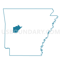
Compton Voting District, Yell County, Arkansas
About
Outline

Summary
| Unique Area Identifier | 528593 |
| Name | Compton Voting District |
| County | Yell County |
| State | Arkansas |
| Area (square miles) | 21.51 |
| Land Area (square miles) | 21.40 |
| Water Area (square miles) | 0.10 |
| % of Land Area | 99.52 |
| % of Water Area | 0.48 |
| Latitude of the Internal Point | 34.94312090 |
| Longtitude of the Internal Point | -93.45303200 |
Maps


Graphs
Select a template below for downloading or customizing gragh for Compton Voting District, Yell County, Arkansas


Neighbors
Neighoring Voting District (by Name) Neighboring Voting District on the Map
- Briggsville Voting District, Yell County, AR
- Crawford Voting District, Yell County, AR
- Herring Voting District, Yell County, AR
- Iron Creek Voting District, Yell County, AR
- Rover Voting District, Yell County, AR
Top 10 Neighboring County Subdivision (by Population) Neighboring County Subdivision on the Map
- Danville township, Yell County, AR (2,882)
- Rover township, Yell County, AR (286)
- Herring township, Yell County, AR (188)
- Briggsville township, Yell County, AR (128)
- Compton township, Yell County, AR (94)
- Ions Creek township, Yell County, AR (88)
- Crawford township, Yell County, AR (43)